Jilly and Piet prepare to travel back to the 1940’s (To the Sheringham 1940’s Weekend), although from Brampton in 2018 – perhaps not such large leap after all…!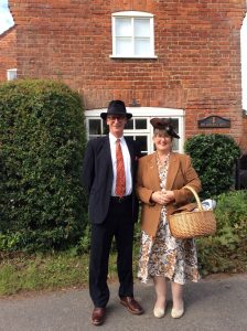
-
Brampton time travelers leap back in time
-
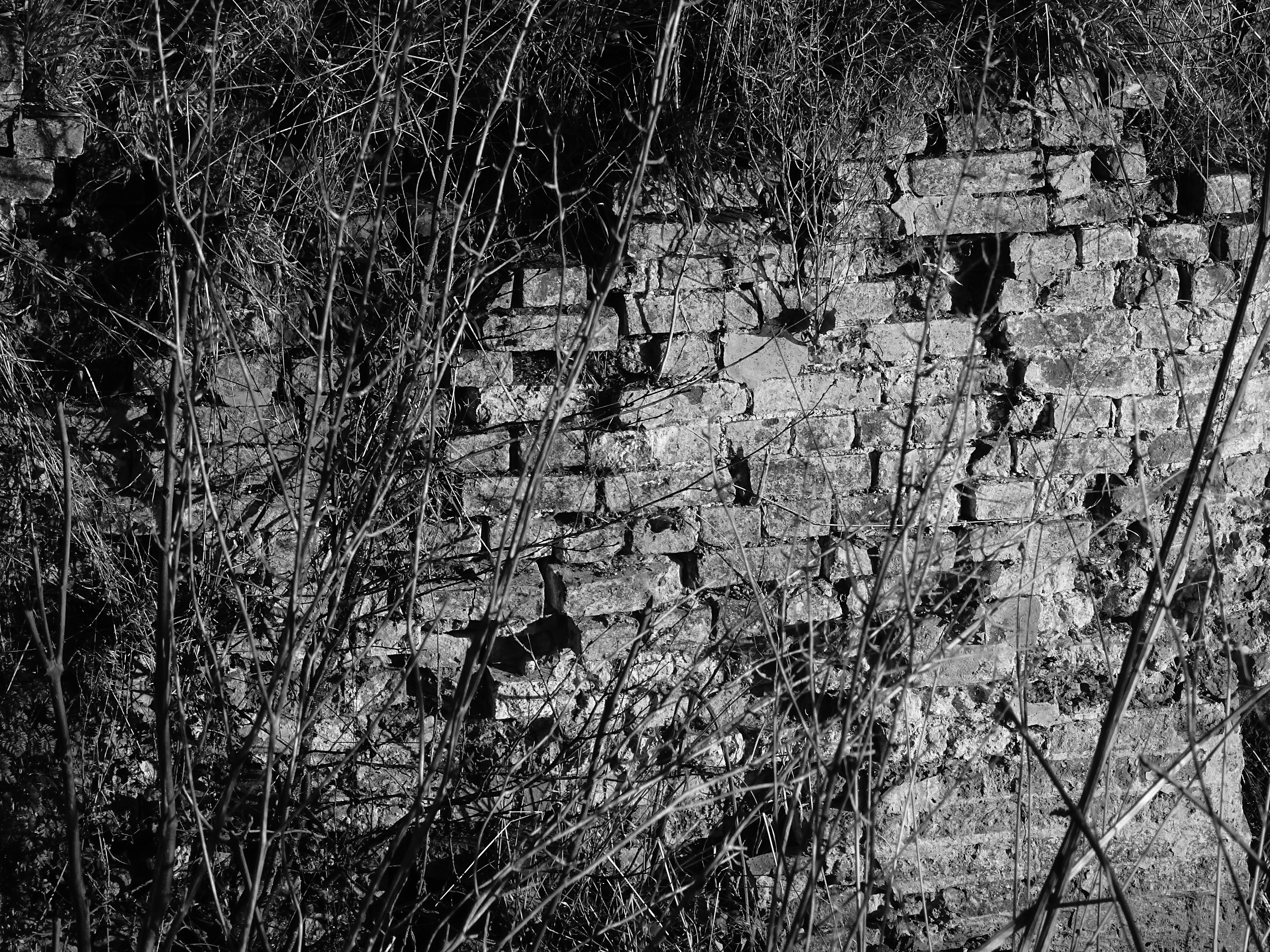
Old brickwork at Oxnead Lock
The decaying brickwork of the Oxnead Lock. According to Edwin Rose (writing in 1993 as part of the Norfolk Archaeological team at Gressenahll) this brickwork was probably built in 1851 when the Mill was refurbished, although it is possible that some parts of the structure may date back to 1775 when the original engineering work on the cut was completed.
-
Lest We Forget
There is to be a Remembrance Service at St Peters, Brampton on Sunday 9th November at 15:30 (3:30pm) – It is 100 years since the start of the so called “Great War to end all wars”. Details of our war memorial are here.
-
An exploration of Roman Brampton – a talk by archaeologist Alice Lyons
Last night at Brampton church Norfolk archaeologist, Alice Lyons, delivered a detailed and enlightening talk upon the Roman history of the village. Or, more specifically, the Roman town which originally lay to the south of the current settlement. A site of both pottery and leather manufacture at a scale unmatched anywhere else in Roman Britain. A site of 150 permanent pottery kilns at Brampton at a time when a 20 kiln site would have been considered big. Busy wharves loading shallow drafted coastal shipping, a stone built bathhouse in an otherwise timber built town. A key communication hub with access to the sea and to major arterial routes. Altogether a contrast to the modern village – how times change.
Alice rounded off the talk by showing some fine examples of Dr Knowles’, and others, finds from the 1970s excavations. These come from those which are held collection in the Norwich Castle museum. She followed this by identifying pottery shards found locally. It was generally agreed that if ever the chance to publish the Knowles archives at the museum, it should be grasped. Perhaps a project for Crowd-funding.
-
A talk on Roman Brampton – to be held at Brampton Church – 27th Saturday 27th September 2014
What do we know of the Brampton Romans?
An illustrated talk to be held at Brampton Church
Saturday 27th September
7.30pmAt St Peter’s Church, Brampton
An illustrated talk by Alice Lyons, a professional archaeologist with a detailed practical knowledge of Norfolk Archaeology, particularly of the Roman period.
Alice will give an illustrated talk of roughly 40 minutes. With some examples of local finds of that period from the Norwich Castle Museum.
Following the talk there will be an opportunity to have any of your own finds identified – Roman or “best Woolworths”?Tickets: £5 per person
Contact Mark Little
-
Wheat harvest
Last Saturday lunch time the Combine Harvester arrived in the village in order to cut the wheat on the 26 acre Town Field. By eight o’clock that evening, not only had the crop had been fully harvested but the straw had been completely baled. All done in roughly 6 hours. By my calculation the wheat crop would produce enough flour on that one field to produce 210,000 large loaves of bread. Incidentally, a quantity which would only be sufficient for 4 minutes worth of the national demand for bread (roughly 12 million loaves per day).
This made me think. At the outbreak if the First World War, crop yields were less than a quarter of those which are attained now. In fact, the yield was probably only enough to provide for 53,000 large loaves. It would have taken nearly three days to harvest the wheat on that same field, and then only if they had the benefit of a modern reaper/binder. Before such machinery was available, three experienced farm workers, along with their families to help gather the sheaves and “shock” the crop would take nearly three weeks to cut the wheat. In all likelihood more than three worker’s families from the village would be involved. No wonder harvest was such an important event. An event which now is limited to a Saturday afternoon. A sad comparison in so many ways, but at least we have enough to eat.
-
Feudal Brampton
For a thousand years the extent of the arable land in Brampton has remained as it was defined in the Doomsday Book. That Norman record reduced the economic activity of the feudal settlement to a single paragraph. The plough lands were said to extend to a Caracute and a Virgate. (A Caracute being an area equivalent to that which could be ploughed by eight oxen in one season and a Virgate being the amount ploughable by two oxen in a season). Thus totalling around 150 acres of better drained land
The actual extent of the plough lands can be roughly estimated today from a large scale OS map as long as you adopt some basic rules. For example, start near the Church as the assumed centre of the village; assume that the modern roads follow ancient routes; ignore the Victorian railway line and trust the line shown as the Parish boundary. If we use the known field names encompassing Hall and Street Farms the area coincides with those known as Church Field, Seven Acres, Kiln Field, Hill Field, Winter Letts, Topletts and the Town Field. It is a very neat fit and 150 acres looms out of the plan.
-
Blown away
Strong winds on Wednesday almost erased another little-noticed piece of
Brampton’s history. An apple tree, rotten of trunk and with no crown to speak of, displays what must be a terminal split. Structurally unsound, but still just standing, it seems unlikely that it will survive for much longer. It’s significance being that it’s origins seem likely to be domestic; planted at the end of a garden or small holding in an area
which seems today to be just farmland. I mentioned the site in an earlier piece (6th November 2011) and I have yet to establish the real recent history of this site.The ancient history of the site is much easier to identify. For the old apple tree
marks the edge of ancient track which leads to what seems to have been a wharf
or loading area on the original shore of the Bure. This was not the Bure as we know now, but the Roman waterway, bustling with shallow drafted sailing vessels collecting the amphorae and other pottery from the nearby industrial town with its many kilns. Within yards the astute observer can cast from the site of a rural dwelling of the nineteenth century to the fourth century AD. -
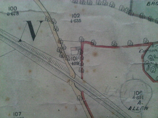
An old dwelling?
I drive past the ghost of a garden every week day. To the left of the Buxton Road just before the bridge, an apple tree clings on to existence on an old hedge line. This is the only mark which remains of a dwelling or smallholding. Upon checking the old maps of the area, the site was clearly occupied as a smallholding when the tithe map of 1837 was produced. By 1885, when the surveyors of the Ordnance Survey were gathering their records, the smallholding seems to have had a dwelling added to it. The map shows a typical part cottage / part barn of the type that you can still detect in some of the older village houses.

- Buxton Road – land near the bridge: the old smallholding
It was only marginally affected by the arrival of the railway line in the 1880’s, although the upheaval must have been enormous. Did the cottage become abandoned then or much later?
By 1946 an aerial photo was taken covering the Parish and the enlarged image, although slightly blurred, appears to show the area being cultivated like an allotment. Perhaps by then the house had been abandoned but the separate smallholding continued.
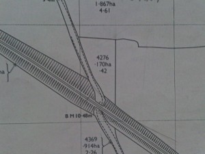
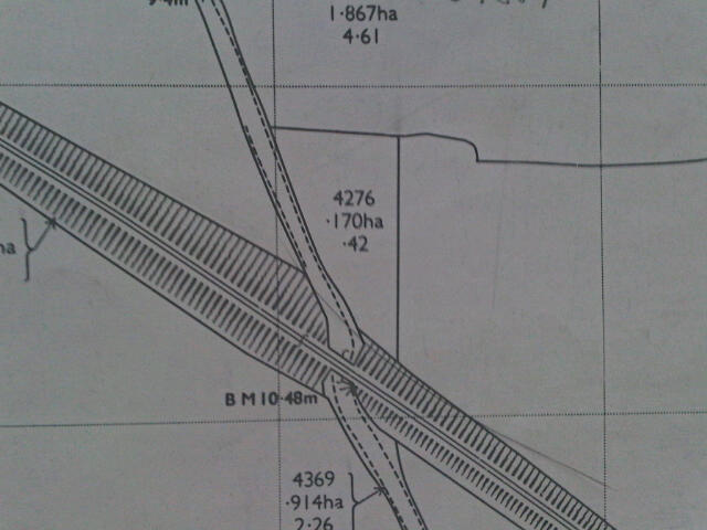
The Buxton Road: modern map showing the same area today Today the latest plans show the shape of the field boundary and only the apple tree remains to mark the spot. No doubt someone in the village knows the history. I would be pleased to know.
-
Brampton, Norfolk

This website is for the village of Brampton in Norfolk. The village is linked through the Parish Council with the neighbouring historic hamlet of Oxnead.
Brampton is one of the smallest villages in Norfolk and is almost certainly the smallest of all the places with the same name throughout the world. The village is located in the valley of the River Bure some 2.5 miles from the market town of Aylsham.
The village sign (above) gives a clue to the fact that the village has a rich history. Archaeological finds go back to the neolithic era but much dates from Roman times when the site was a bustling industrial centre with maritime links to the rest of the empire. Pottery and metal products were the main items manufactured here. The village sign is based on a Roman artefact discovered in the village which can now be seen in Norwich Castle Museum. Excavations in the 1960’s & 70’s uncovered a Roman bath house and much evidence of industrial activity. It also identified the location of the port area from where the manufactured items were exported.
The River Bure was navigable through Brampton until 1912 when wherries (Norfolk cargo carrying river boats) would transit to the mill at Aylsham. Brampton itself had a staithe (landing place) and at least one wherry was based here. Today the head of navigation is Coltishall from where the Bure forms an important part of the Broads network as it wends its way to Great Yarmouth.
Today the village is unspoilt and very quiet. Visitors on foot, bike or horseback are very welcome but our narrow lanes and lack of parking makes a visit by car very difficult. There is a station at Brampton on the Bure Valley Railway; a footpath and cycle way runs alongside.
There are a number of footpaths in and around Brampton. One of the favourites is the causeway path (known as the ‘Karnser’) that leads to Burgh-next-Aylsham. This route crosses the Bure by way of the Cradle Bridge and then crosses the churchyard of St. Mary’s Church in Burgh.
St. Peter’s Church Brampton lies at the north of the village at the end of a shallow ridge which overlooks the river valley. The church is one of the 124 ‘round-tower’ churches of Norfolk and is Grade II* Listed Building.
